Huge Storm Heading for the Midwest with Heavy Snow, Blizzard Conditions
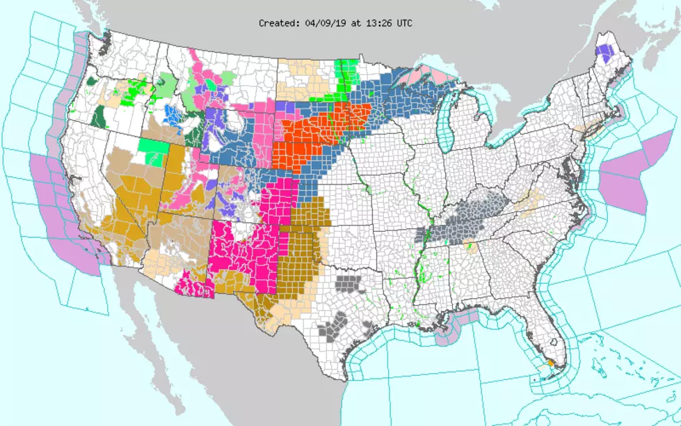
Looking at all the colors on that weather map just makes me shudder. It's April 10th, but Mother Nature isn't paying attention to the calendar. She's intent on bringing miserable conditions to a large part of the country in the coming days. The National Weather Service says the late-winter storm bound for the midwest "is expected to intensify rapidly late Tuesday into Wednesday." Here's what to expect from Winter Storm Wesley.
So what's going to happen and where? The graphic below from KIMT in Mason City does a great job of laying it out. Extreme northern Iowa, and especially Minnesota, Nebraska, and South Dakota are clearly in this storm's bullseye. CBS 2 Chief Meteorologist Terry Swails says the National Weather Service in South Dakota says the storm has the potential to be historic. I think we can all agree we've seen enough historic weather this winter season.
In our listening area, we'll likely just see rain, along with plenty of wind...with a potential for a trace to 3 inches of snow...and it will continue off and on through the rest of the work week. Unfortunately, it could be heavy. Our rivers definitely don't need that, especially with heavy precipitation again forecast to our north.

More From 97.7 KCRR

![Big Events Happening This April in Eastern Iowa [LIST]](http://townsquare.media/site/675/files/2024/03/attachment-Add-a-little-bit-of-body-text-15.jpg?w=980&q=75)